

VERTICAL FACADE INSPECTION PLATFORM
Software Development
Vertify Analytics
Two Trees Development, one of New York City’s leading real estate developers, contracted us to create a software solution that would re imagine how Local Law 11 inspections were conducted, managed and organized.
We developed a digital solution to optimize Local Law 11 inspections, using drone photography to accurately image 100% of a building’s envelope, then organize the data into an accessible format that streamlined the inspection and reporting process.
STATUS QUO
Façade inspection is one of the most routine operations in property management, yet remains dangerous and inefficient due to the difficulties of accessing a vertical building façade.
Current methods of data collection rely on outdated techniques like binoculars, bucket cranes and single-scaffolding drops to determine an average status of the entire building.
These methods incorporate assumptions and guesswork which negatively impact work assessments, public safety and keeps scaffolding built far longer than necessary.

PROJECT SCOPE
In order to satisfy the Local Law 11 requirement and concentrate restoration efforts, we were tasked with developing a way to provide 100% photographic coverage for four [4] distinct buildings located in Dumbo Brooklyn.
Given the scale of the project, we knew a custom software platform was necessary to correctly capture, process and organize the data for our client. Our key considerations were to build a product that provided the high-resolution imagery needed for inspections, while keeping the platform nimble, organized and process oriented.


SOFTWARE BUILD - CONTENT CAPTURE
Our solution was to design a piece of software that could automatically categorize and manage large quantities of high resolution drone photographs.
In order to make this work, we had to develop an on-board application that standardized the distance between the drone and the facade to maintain a consistent perspective.
Our development team began working within the DJI SDK and developed a program that took advantage of data created by the on-board altimeter.
A key consideration through development was building a program that still worked with all the software parameters designed by the drone manufacturer, specifically obstacle avoidance and pre-programmed geofencing.


PATTERN CREATED BY ALTITUDE AND GPS DATA RECORDED ON-BOARD THE UAV
CONTENT CAPTURE RESULTS
The on-board application allowed us to get standardized photography across each facade allowing for detailed inspection.
By stitching these individual images together, we were able to produce a high-resolution grid map that could simultaneously function as a photographic site elevation and a high-resolution survey of the entire building envelope.


4
ENTIRE BUILDINGS SCANNED
92,320 sqft
OF VERTICAL FACADE COVERED
6 hours
TO COMPLETE ENTIRE STUDY
SOFTWARE PLATFORM - CLIENT EXPERIENCE
In order to present this to the client, we developed a cloud-based platform that would organize the thousands of images in a grid format allowing the client and the engineering team to conduct a collaborative inspection remotely.
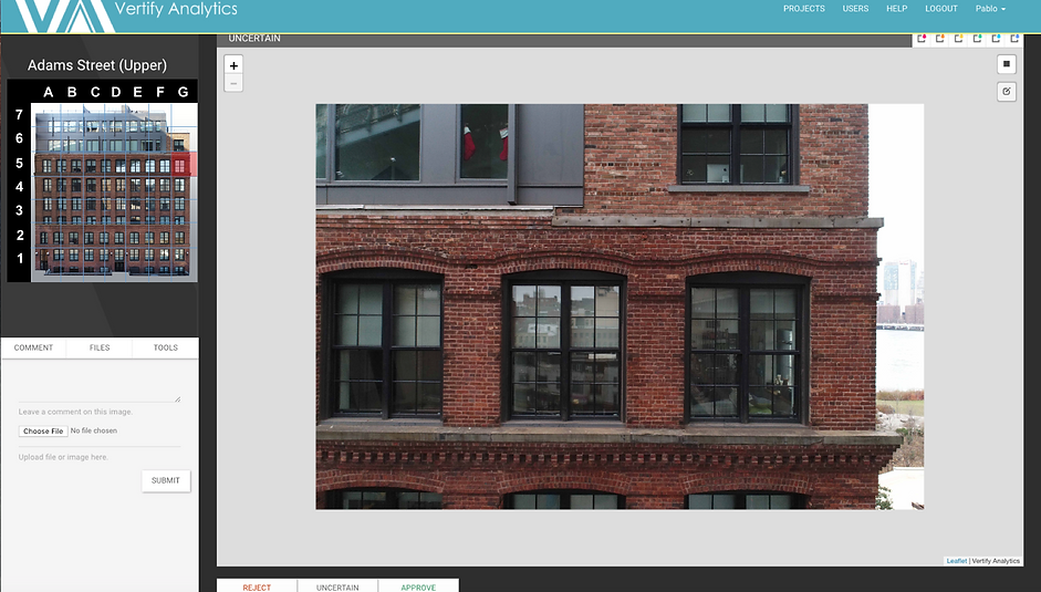
ONLINE PLATFORM - CLIENT VIEW
By giving each user a unique marker color, we gave the engineers a way to communicate and mark repairs directly on the image data, making the inspection process more efficient for all parties

Marked repairs would be categorized into standardized reporting format designed to integrate directly with the existing Department of Buildings Local Law 11 reporting format.

KEY PRODUCT APPLICATIONS
LOCAL LAW ORDINANCE
Detailed photographic evidence for civil and client reporting, while providing the best information to engineers
BIDS & WORK ORDERS
A tool to prevent future change orders with 100% visual coverage with which to base repair scope
EXISTING CONDITION SURVEYS
Conduct detailed analysis of neighboring properties to develop existing condition surveys and protect against future litigation